
A mile by mile fly-through of the ATR route.
This is not intended to replace RD Robert Sanderson’s race brief and maps he will offer. Merely, it is a guide for those who have never been on the route or couldn’t make the recce runs recently. It gives a feel for how the race plays out. Strategy wise, I would say run hard when you can but save something for those hills towards the end! Shoes, light trail are usually OK unless it has been raining heavy and I will wear Hoka Evo Stinsons on the day.
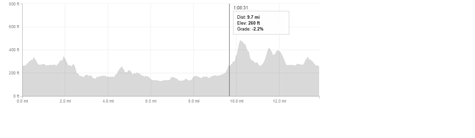
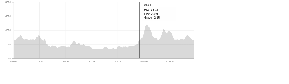
Firstly, here is a Strava record of the race from last year: http://www.strava.com/activities/90203316
Mile 1: Starts alongside Dullatur Golf Course with a 500m slight uphill run on rough stone path. Gives way to a hard packed wide path, slightly downhill before coming to a railway bridge.
2015 update: the stone path has now been tarmac’d as part of the Sustrans project and is now a smooth path.

Mile 2: Crosses over the bridge onto a single track trail for about 150 yards, then into the bit which can get boggy as you run through a short wood and through a gate, then a hard right onto a nice soft land rover track.
2015 update: The boggy bit seems to have gotten worse with some drainage issues this year, and even after periods of dry weather is rather, well, boggy.
Mile 3:… Starts as two finishes, heading downhill, a left turn takes you to another gate which goes on to a hard packed path which quickly turns into a sharp downhill and into area known locally as Nash’s
Mile 4: Goes towards the Boathouse at Auchinstarry Marina. Running along the canal (not the towpath side). You then cross the canal road bridge, running on tarmac for the first time, before going into Auchinstarry Quarry and toward the Coach Road.
Mile 5: Goes from the tarmac of the Coach Road to the most bonafide trail section of the race, about 1km of ferns, jaggies and watchyerfootinghere running. Comes out on a hard packed path in Kilsyth. You need watch for the hard left to get on the trail, otherwise you’ve gone too far.
Mile 6: Goes through the market town of Kilsyth. Firstly the Burngreen and on the red ash path behind the old doctor’s surgery and library, then past the park with the brilliant bandstand, and then follows the Garrell Burn into the Kelvin Valley. Very flat and fast here.
Miles 7-8: Follows the trail path through Drumbeck Marshes. The trail goes from smooth to stoney to smooth and there are a couple of quirky wee turns here, especially at around 7.5 miles.
Mile 9: Takes you onto the canal towpath heading to Glasgow. About 0.5 mile in you go down a hidden flight of stairs and under the canal and into Twechar. Coming out at the sports centre.
Mile 10: The first proper hill. Around 300ft of climbing in a km. Very sharp at the end. This takes the runners back towards Croy Hill. There is a quick respite of a downhill straight after. Beautiful bit of the route which goes through the Creecy Wood and is a lush forest trail. When not wet…
Mile 11: Pretty much downhill towards Croy. Trail, couple of gates to get through and very runnable.
Mile 12: The second of the big hills. A bit sharper than mile 10 but shorter and not as high. Can take the wind out of you if you are not ready for it. Runs squarely into Croy Hill and alongside the Antonine Wall. You finish this mile by getting to the very top of the hill and heading back down.
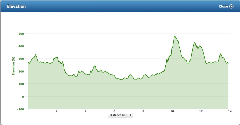
Mile 13: Straight down Croy hill and you get to what is 1.5 miles from home, retracing the opening 1.5 miles. All on grass and wide trail. There are embedded rocks on this section that need to be paid attention to if you are flying down the hill. Mile finishes by crossing over Dullatur Railway bridge and heading back towards Croy.
Mile 14: The first mile reversed. There are two wee snidey bastard hills in this section and trying to sprint on the loose type 1 after 13 and bit gruelling miles isn’t easy.
2015 update: same as mile one, no longer loose stone but tarmac. Will suit a fast finisher.

Loved it well done James a lot better than I could do😀
Nae bother!